For detailed information, including a map of the trail and further insights into the hike, please visit:
https://whatson.fo/hiking/hike/haraldssund-skard?lang=en
There you’ll find everything you need to prepare for the hike and navigate the route safely.
This awe-inspiring hike follows the dramatic coastline from Haraldssund to the abandoned village of Skarð on the island of Kunoy. Along the way, you’ll walk close to the sea with towering mountains and steep cliffs rising above you.
The route offers a unique combination of nature, history, and powerful Faroese landscapes.
The hike begins near the boat basin north of the village of Haraldssund. As you move along the shore, the path gradually becomes easier to follow.
Several brooks and streams cross the route as they run down toward the sea. Be careful when crossing areas of exposed bedrock, as they can become slippery.
For centuries, this path served as an important connection between Haraldssund and Skarð. In earlier times, people frequently travelled between the two villages along this very route.
Haraldssund is believed to be a very old settlement, much like the nearby villages of Kunoy and Skarð. In the past, the villages on Kunoy kept their boathouses in Fiskimøl, just south of where the tunnel entrance stands today.
The hike follows the coastline closely. As you walk, you’ll hear the waves crashing against the cliffs while steep mountains rise dramatically above the narrow coastal strip.
Kunoy is the highest island in the Faroe Islands and has six of the country’s ten mountains above 800 metres. Many parts of the island are difficult to access, and hikers should avoid venturing into the mountains without an experienced guide.
After about 1.5 km, you reach Skarðsmannastíggj, a historic path once used by the men of Skarð.
When fishing with the men from Haraldssund, they would row south along the coast to a rocky landing. From there, they walked back north to Skarð along this path.
The people of Skarð also kept a boathouse in Búðadal. The ruins can still be seen just north of Búðadal Lake, which once marked the boundary between the two villages. When the sea conditions were too rough in Skarð, fishermen used the landing here or rowed to Haraldssund.
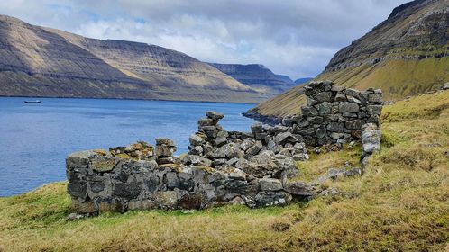
After around 5 km, the ruins of Skarð begin to appear near the shoreline. From a distance, the remains of the houses look surprisingly small against the dramatic landscape.
As you approach Skarðdalur, steep rock walls beneath Kúvingarfjall and Middagsfjall rise above the valley. From the village site, you can also see Skarðsgjógv, the largest gorge in the Faroe Islands.
Follow the path north of the village past the waterfall in Skarðdalsá. On the opposite side of the river lies Skálatoftir, another ruined settlement. Continue past the stone fence until you reach the house ruins of Skarð.
From the village, a path leads down to Kleivina, where it becomes clear how difficult it once was for the villagers to launch their boats.
On December 23, 1913, tragedy struck. Seven men from Skarð set out to sea but were caught in sudden bad weather. Their boat sank, and all seven were lost. The village lost its entire group of working men in a single day.
Life became extremely difficult for the remaining residents. By 1919, the village was completely abandoned.
Today, a memorial in Skarð honors the men who lost their lives at sea.
Skarð is a powerful and peaceful place. The surrounding mountains, ocean views, and quiet ruins create a unique atmosphere.
Take time to pause, explore the area, and reflect before beginning the hike back.
Some hikers continue from Skarð through the gorge toward Kunoy, climbing to an elevation of 618 metres. However, this route is extremely challenging and should only be attempted with an experienced guide.
The terrain is steep and navigation can be difficult. This extension is recommended only for very experienced and well-prepared hikers.
