For detailed information, including a map of the trail and further insights into the hike, please visit:
https://whatson.fo/hiking/hike/mikladal-husar?lang=en
There you’ll find everything you need to prepare for the hike and navigate the route safely.
This peaceful hike leads across five valleys between Mikladalur and Húsar on the island of Kalsoy. Along the way you’ll enjoy magnificent views of steep mountains, dramatic cliffs, and the surrounding fjords.
The trail forms part of a longer 14.5 km route between Syðradalur and Trøllanes, which normally takes about 4.5 hours to complete. Historically, this route was very important. Both Mikladalur and Trøllanes are exposed to heavy surf, which often made it impossible to reach the villages by boat. The mountain path therefore served as the main connection between settlements.
The hike begins in Mikladalur, near the large bend in Sevgrøv, just outside the village where a shortcut leads up toward Lítladalur.
The path is visible and fairly easy to follow along most of the route. Only in the valleys Ritudalur and Villingadalur does the trail become less distinct.
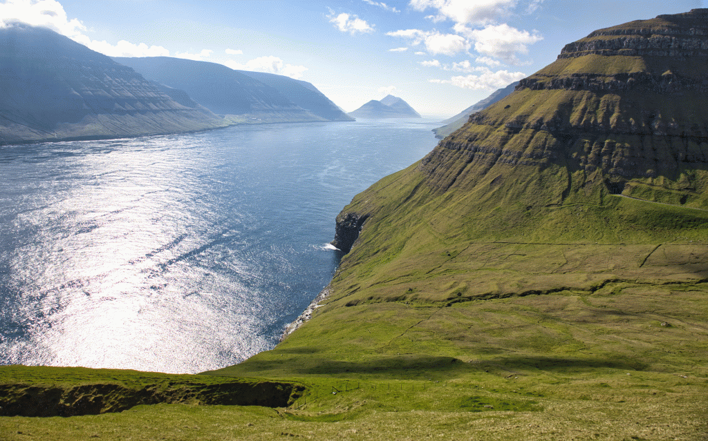
Climbing out of Mikladalur offers spectacular views. Below lies the village itself, while above rises Nestindar at 788 metres. Looking east, you’ll see the steep cliffs of Kalsoy, and across the fjord the towering mountains of Kunoy. From above, you may also spot the famous Seal Woman statue (Kópakonan) near the shore.
The walk south toward Ritudalur feels quick and gentle. Once in the valley, the path follows a winding shortcut that clearly shows how frequently the route was used in earlier times.
Near the large hill in the valley you’ll find an unusual curiosity — an old “money hole.” A sign once read “Good cause.” According to local stories, travellers passing by would toss spare coins into the hole. No one seems to know who originally collected the money or how it was used.
Leaving Ritudalur, the route continues south through Bustin toward Villingadalur. From there, follow the path around the valley and further south into the area called Lundurðarnar.
Here you will see two paths. Be sure to take the upper path, which leads toward Lunnarsgjógv, the natural boundary between the villages of Mikladalur and Húsar.
From Lunnarsgjógv, continue south with impressive views of Hattardalstindur, rising 644 metres above the landscape. The final part of the hike leads into Hattardalur, where the trail eventually joins the main road.
From here, it is easy to continue down toward the village of Húsar.
This hike offers a wonderful combination of peaceful valleys, historic paths, and dramatic Faroese mountain scenery.
