For detailed information, including a map of the trail and further insights into the hike, please visit:
https://whatson.fo/hiking/hike/muli-skalatoftir-strond?lang=en
There you’ll find everything you need to prepare for the hike and navigate the route safely.
This impressive hike begins in the remote village of Múli on the island of Borðoy. From there, the trail leads between towering mountains and along steep coastal paths toward the abandoned village of Skálatoftir.
The route offers spectacular views and a strong sense of Faroese history. However, parts of the trail are exposed, so it is not recommended for hikers with a fear of heights. It should also only be attempted during dry summer weather, when conditions are safest.
The hike begins in the quiet and historic village of Múli, located on the northeastern side of Borðoy. Arriving here feels peaceful and almost mysterious.
Local legend tells of Guttorm í Múla, believed to have been the most famous wizard in the Faroe Islands. His reputation still adds to the magical atmosphere of the place.
Today, no permanent residents remain in Múli.
Walk through the village along the grassy terrain on the northern side. After about 100 metres, you will reach a fence and a stone gate. From there, continue north along the fence and through the gate. Shortly after, the terrain opens onto the flat area called Hagabrúgv.
At first, the trail is not very visible. However, once you reach a sheep shelter about 200 metres north, the path becomes clearer and easier to follow.
As you continue, the trail begins to climb along the northern slopes. In a few places the path splits — here you should choose the upper trail both times.
While heading west, the island of Kunoy appears across the fjord. At around 100 metres above sea level, the route follows the old village path around the headland of Múli.
After circling the headland, the trail turns south. Just above Fuglatúvuna, you reach the steepest section of the route. During calm summer weather this stretch is manageable for hikers who are comfortable with heights. In winter, however, the conditions can become dangerous due to wet ground and the steep drop toward the ocean.
South of Ørmansdalur, the path continues through Múlagjógv and several deep gullies. These sections offer impressive views down the cliffs toward the sea.
Beyond Ørmansdalur the terrain becomes less steep, making the walking easier.
About one kilometre further south lies Ásagjógv, where boats could once seek shelter during bad weather. Fishermen sometimes pulled their boats onto the sand in the gorge and spent the night there when conditions at sea were too rough.
Today only a rusted iron staple remains as a reminder of this old landing place, and the descent into the gorge is no longer recommended.
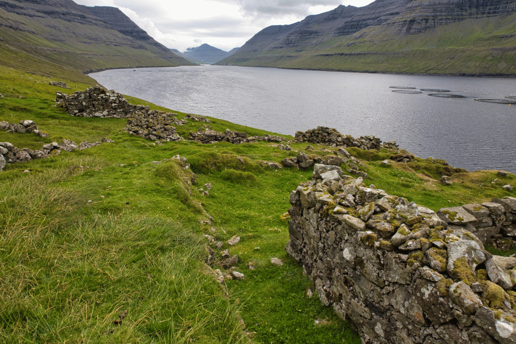
Soon after passing Ásagjógv, the abandoned village of Skálatoftir comes into view. The green fields and stone ruins make it easy to imagine what life was once like here.
Skálatoftir consisted of six houses, though only four were inhabited at its peak. Around 1880, the small settlement had about 23 residents, which was likely the highest population the village ever reached.
Three of the houses were connected, forming a row: Kongsstovan, Roykstovan, and Innistovan.
From the northernmost house, steps lead down to the landing place known as Kleivina, where the foundations of old boathouses can still be seen. Despite their age and the grass that now covers them, the stone steps remain surprisingly intact.
From the village ruins, follow the grassy path southward. Eventually you will reconnect with the village path leading through the stone gate.
The first part of this section is paved. As you continue, the landscape opens up with views across the fjord toward some of the highest mountains in the Faroe Islands, as well as Skarðsgjógv, the country’s largest gorge.
Before long, the trail leads down toward Strond, near the embankment at Haraldssund, where the hike ends.
