For detailed information, including a map of the trail and further insights into the hike, please visit:
https://whatson.fo/hiking/hike/nordtoftir-klaksvik?lang=en
There you’ll find everything you need to prepare for the hike and navigate the route safely.
This scenic hike leads through the dramatic mountains north of Klaksvík, across the historic outfields once owned by the Faroese national hero Nólsoyar Páll, and past the ancient thingstead Katlarnir.
Along the way you’ll experience open landscapes, historic sites, and magnificent views across the fjords and valleys of the Northern Isles.
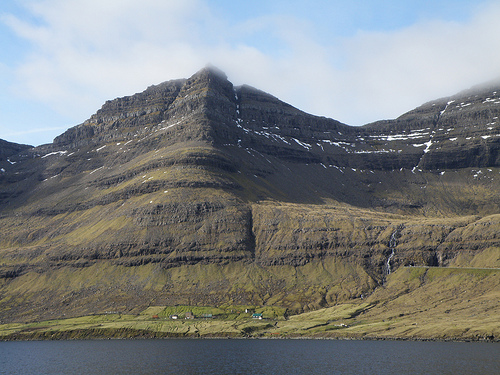
The hike begins at the infield gate above Undir Kráarbrekku 21 in Klaksvík, an area also known as Rynkeby.
From here, follow the village path north through the pastures of Myrkjanoyrarhagi, passing a small cottage along the way.
This outfield once belonged to Nólsoyar Páll (1766–1809), one of the most famous figures in Faroese history. He was a shipbuilder, captain, farmer, and poet.
Nólsoyar Páll is known for writing the satirical ballad Fuglakvæðið (The Bird Ballad), where birds symbolized people in the community. The poem angered Danish authorities but entertained many locals.
He disappeared during a voyage in the winter of 1808–1809. Today, his farm is being reconstructed at Biskupstøð in Klaksvík, which is worth visiting during your trip.
The trail continues through historic peat fields, where people from Klaksvík once cut and dried peat for fuel. In several places you can still see remains of old turf houses used during this work.
The area is also rich in birdlife. Species commonly seen here include Curlew, Oystercatcher, Golden Plover, Snipe, and Herring Gull.
As you climb above Ánir and approach Áarskarð, the terrain becomes more rugged. Some sections may be slippery in wet weather, so walk carefully.
The pass at Áarskarð offers spectacular views. Below lies the village of Árnafjørður, surrounded by steep mountains. To the south you can see Lisshøvdi, while the valley below reveals the ancient site Katlarnir.
On either side rise two prominent peaks: Snæfelli to the north and Myrkjanoyrarfjall to the south.
A short detour leads to Katlarnir, the historic thingstead of the Northern Isles. For centuries, this was the place where local assemblies were held and disputes were settled.
Parliament sessions were held here during springtime. The exact origin of the site is unknown, but evidence suggests it ceased to be used around 1670–1680.
The site contains several large Thing stones, including the main stone known as Tingsteinurin, along with smaller stones that may have been used during gatherings.
To reach Katlarnir, walk diagonally down into the valley through the area called Niðari Snæhjalli. Cairns mark the route, although some may be difficult to see. After crossing a fence and a small stream, you will arrive at the historic site.
From here you may either return to Klaksvík the same way or continue toward Árnafjørður.
If you choose to continue, walk about 500 metres back toward Áarskarð, but remain at roughly the same elevation instead of climbing the pass again.
Continue toward Rossastígar, where a narrow passage between rocks leads down the mountain. Aim for the scout hut below, where you will find the path leading down toward the road between the two tunnels.
Along the way you pass a large boulder called Grindasteinur (Pilot Whale Boulder). According to local tradition, news of a pilot whale hunt was once shouted from this spot down to the village of Árnafjørður.
The descent through Ovarustígar, also known as upp í Jørnunum, can be challenging. The path follows an iron fence and includes steps carved into the rock. Cairns and reflector posts mark the route.
Eventually the path reaches the road between the two tunnels. From there it is about one kilometre to Árnafjørður.
From the tunnels, walk past the building known as Minhúsið. The villagers of Árnafjørður built this structure during World War II as shelter from sea mines that sometimes drifted into the bay and exploded.
From there, follow the path Válagøtan, which runs along the ridge down toward the village, located just east of the river Stórá and the church.
Árnafjørður is one of the oldest settlements in the Northern Isles. Today, many residents work in salmon farming, and the fjord is also known for lobster fishing.
The hike can be taken in either direction. However, the ascent is generally more demanding when starting from Árnafjørður.
